
Tropical cyclones or hurricanes threaten the lives of millions and cause billions of dollars in damage every year. To estimate flood risks at a particular location, scientists and engineers typically start by looking at the historical record of all previous storms there. From these records, they can statistically predict how likely a storm of a given size is (e.g., the biggest storm likely to occur there in 100 years).
There are two problems with this approach: (1) What if there isn’t much historical data in the records? This is often the case for Small Island Developing States (SIDS) and in the Global South. If you don’t have enough data points (particularly for rarer, more extreme events), your statistical estimates will be much more uncertain. (2) What if the historical record isn’t representative of the conditions we are likely to see in the present and future? This is also a big problem in light of climate change, which is expected to bring sea level rise and changes in storminess to coasts around the world.
To address these challenges, our team led by Tije Bakker came up with a new approach to estimating tropical cyclone-induced hazards like wind, waves, and storm surge in areas with limited historical data. Our findings are now published open-access in Coastal Engineering here!
A useful solution to these problems is to generate many synthetic but realistic cyclones for our site of interest, allowing us to essentially go where no cyclone has gone before. My Deltares colleagues Kees Nederhoff and Tim Leijnse have developed tools for easily creating thousands of these artificial cyclone tracks, extending our predictive capabilities.

However, if we want to estimate the coastal hazards like waves and storm surge for a given location, we also need to run a computer simulation of the waves and water motion during that storm. We can then extract wave heights and storm surge from the locations we are interested in, and perform an extreme value analysis to estimate flooding probabilities, as is common in flood risk estimates. However, these hydrodynamic models take a lot of computer power and time to run, which means that it is impractical to simulate thousands of storms.
Tije’s new method helps us greatly reduce the number of simulations that need to be carried out, by selecting a much smaller subset of synthetic cyclone tracks that are representative for the site of interest. We do so by choosing cyclones that pass near the site and cover a wide range of wind conditions, including the most extreme conditions, which are necessary to account for in engineering and flood protection designs. For the nitty-gritty details, check out the paper!
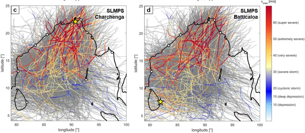
The end result is that Tije’s approach narrows down large datasets of synthetic cyclone tracks to a handful of statistically representative ones. This reduces the number of expensive model simulations needed by 90%, while preserving accuracy within 10%. This will lead to better predictions of cyclone impacts, hopefully saving lives and money!
References
- *Bakker, T., Antolinez, J.A.A., Leijse, T., Pearson, S.G. & Giardino, A. (2022). Estimating tropical cyclone-induced wind, waves, and surge: a general methodology based on representative tracks. Coastal Engineering. [Link].
- Leijnse, T. W. B., Giardino, A., Nederhoff, K., & Caires, S. (2022). Generating reliable estimates of tropical-cyclone-induced coastal hazards along the Bay of Bengal for current and future climates using synthetic tracks. Natural Hazards and Earth System Sciences, 22(6), 1863-1891. [Link].
- Nederhoff, K., Hoek, J., Leijnse, T., van Ormondt, M., Caires, S., & Giardino, A. (2021). Simulating synthetic tropical cyclone tracks for statistically reliable wind and pressure estimations. Natural Hazards and Earth System Sciences, 21(3), 861-878. [Link]
