When you think of coastal climate change impacts, what do you think of? Probably sea level rise, changes in wave climate or storminess, or loss of coastal habitat. But a silent intruder lurks: salty seawater, sneaking into estuaries and rendering our precious freshwater supplies undrinkable. The threat of estuarine salinity on deltas and coastal regions is one that I greatly underestimated, even as someone working in this field for over a decade. That is, until Gijs Hendrickx came along.
Coral reefs act as essential flood protection for low-lying tropical coasts, something that is making the newsfrequentlythese days. However, as I have explained before on this website, Weird Waves Cause Big Trouble on Small Islands in the Middle of the Big Blue Wet Thing. Essentially, some coral reefs have a tendency to excite normally idyllic swell waves into dangerous resonant low-frequency waves that can act like mini-tsunamis and flood vulnerable low-lying tropical islands. When pushing a child on a swing, you can send them higher and higher with relatively little effort by timing your pushes carefully. In the same manner, waves striking a coral reef can be naturally amplified higher and higher if they are timed at just the right frequency. This can happen even on a sunny day – big storms not necessary! Suffice it to say, this is bad news for islands that are already barely above sea level.
Over the past decade or so, research on this topic by my colleagues and I has focused mostly on how the shape of the coral reef, specific wave conditions, or the combination of both can lead to resonant conditions. But up until now, we have largely stuck to the simplifying assumption that once resonant conditions are met, they stay that way for a while. But is this actually the case? How long do resonant conditions last on coral reefs, when do they occur, and what are the consequences for flooding?
To get to the bottom of this, Bernice van der Kooij came to the rescue! Last week she successfully defended her master’s thesis, Exploring Transient Resonant Behaviour over a Fringing Coral Reef. In Bernice’s thesis (which is simply a joy to say out loud), she dove deep into the mechanics of a complex mathematical technique, the Hilbert-Huang Transform. Bernice did some extremely difficult work that certainly kept her thesis committee on its toes. Armed with this approach, she managed to find that while these intense low-frequency wave conditions typically lasted about 5 minutes, they tended to last for hours during major flooding events.
These floods underscore the urgency of the problem Bernice worked on, and we are very proud of her and her research. We wish her all the best in the next steps of her career!
My colleague Matthieu de Schipper and I are looking for a new PhD candidate as part of the large SOURCE research project! SOURCE stands for Sand nourishment strategies for sustainable Coastal Ecosystems. The SOURCE philosophy is that carefully planned sand nourishments now will create the required and desired resilient and dynamic multifunctional coastal landscapes of the future.
Sand nourishment has been essential in the Dutch government’s strategy to sustainably maintain flood protection levels along the Dutch coast for more than 30 years. Nourishment volumes are projected to increase to keep up with the expected acceleration in sea level rise. However, we currently lack fundamental knowledge on how the nourished sand finds its way through the coastal system, and what the long-term, cumulative effects are for the coast as an ecosystem. For instance, we know that beaches that are nourished with sand in the nearshore are eroding less, but which sediment is accumulating on the landward beach is still unknown. Likewise it is still unknown which hydrodynamic and sediment transport processes dominate in the vicinity of a nourishment.
In its entirety, the SOURCE research team will deliver the scientific knowledge, models and design tools to develop and evaluate nourishment strategies in a multi-stakeholder co-creation process. Our Living Labs are two sand nourishments along the Dutch coast. These will be co-designed, monitored and evaluated by the SOURCE consortium (in particular the 12 PhD and postdoc researchers at 8 academic institutes in total) in collaboration with 25 partners from government organizations, research institutes, nature organizations and industry.
As part of the SOURCE project, the PhD candidate at Delft University of Technology will examine the morphological development of shoreface nourishments. Understanding the hydrodynamics and sediment transport are key in this research. You will therefore use state-of-the-art field equipment and strategic numerical modelling to unravel the physical processes shaping nourishments. This will ultimately contribute to the robustness of (Dutch) sandy coasts to climate change and the safety of its people against flood hazards.
You will:
Plan, execute and analyse field observations at a nourished beach to better understand the impact of nourishments on the hydrodynamics, sediment transport, and morphological evolution.
Use strategic modelling to predict coastal sediment pathways at recently nourished beaches and the origin of sediment accumulated in the lee side.
Combine data and findings of multiple nourishment projects to show the link between engineering design and coastal settings on the nourishment performance. This step will require you to collaborate with government and industry partners (abroad).
Collaborate with academic partners in the SOURCE project to translate quantitative metrics of physical beach response to ecological and socio-economic impacts.
At TU Delft, you will be part of the Coastal Engineering section where we combine research on hydrodynamics, morphodynamics, and human interventions to the coast using numerical modelling and field measurements. You will primarily work with Matthieu de Schipper and myself (Stuart Pearson), embedded within a larger ecosystem of research partners.
More information about the topic and the application process can be found here.
Come join our team! Feel free to get in touch with us (s.g.pearson@tudelft.nl) if you have any questions. Applications close July 21st, 2024!
Mangrove forests provide valuable coastal habitats but also provide a natural form of coastal flood protection and a host of other services. However, many of these mangrove forests are threatened by coastal development and groundwater pumping-induced subsidence, among other natural and human changes. Part of the challenge is that mangroves are extremely choosy about their habitat, and need just the right combination of tidal submergence and mud to take root. If these habitats are thrown out of balance by people or natural causes, it becomes hard for new mangrove seedlings to grow there and sustain the forest.
To make happier places for the mangroves to develop, different kinds of coastal fences/dams have been proposed. The general principle is that waves and currents are attenuated or blocked by the fences, which makes a nice quiet area behind them for mud to accumulate and mangrove propagules to take root. What impact do these structures have on the coastal “conveyor belt” transporting mud and propagules? Enter Nirubha Raghavi Thillaigovindarasu!
Just before Christmas, Raghavi successfully defended her thesis, “Mangrove-Sediment Connectivity in the Presence of Structures Used to Aid Restoration“. Beginning with a numerical model of a site in Indonesia to simulate the motion of rivers and tides, she then applied the SedTRAILS model to visualize and interpret the pathways of sediment and mangrove propagules as they journeyed along the coast. By adding structures to her model, she was able to demonstrate how this trapping behaviour has an influence in the vicinity of a structure but also up to a kilometer away.
How can we ensure that vulnerable coasts and deltas remain robust to the effects of climate change? We need to better understand how sediment moves along our coasts and deltas, and plan to do so by treating coastal systems as networks of interconnected sediment pathways.
We are looking for a curious and motivated PhD candidate to work with us on an exciting project here at TU Delft in the Netherlands. The main goal of this position is to develop novel approaches to quantify sediment pathways and connectivity, and to use these approaches to inform coastal sediment management.
Our main strategy for ensuring the climate-robustness of the Dutch coast is to nourish or place sand to widen its beaches and dunes. However, the fate of sand placed on the coast is still poorly understood in the context of the full coastal system. Understanding where nourished sand goes is necessarily rooted in understanding the natural sediment transport pathways and connectivity of the system. To take advantage of advances in the field of network analysis and extend these concepts to analyzing sediment transport pathways in coastal systems, we established the framework of coastal sediment connectivity (Pearson et al., 2020).
In this project, you will advance coastal engineering by introducing established techniques from other fields (e.g., network analysis) in a novel way to understand and predict sediment transport. These techniques will yield a new and useful toolbox of methods for predicting and understanding sediment pathways, and enable more efficient and effective nourishment design and execution. This will ultimately contribute to the robustness of the Dutch coast to climate change and the safety of its people against flood hazards.
In this PhD, you will:
Apply network analysis techniques to better understand how sediment pathways are connected at small/short and large/long space/time scales.
Use coastal sediment connectivity networks to probabilistically model sediment pathways via Markov chains or machine learning approaches.
Quantify (a)synchronization of coastal sediment networks and relate to hydrodynamic forcing.
Relate quantitative metrics of network structure to practical coastal management goals (eg, identifying resilience or tipping points).
At TU Delft, you will be part of the Coastal Engineering section where we combine research on hydrodynamics, morphodynamics, and human interventions to the coast using numerical modeling and field measurements. You will primarily work with me (Stuart Pearson) and Ad Reniers, embedded within a larger ecosystem of research partners.
Have you ever walked along a windy beach and noticed shells sitting atop small peaks of sand, like a miniature mountain range? Does a shell “protect” the sand underneath, or does the sand pile up behind it? Does the shell actually cause more erosion around it? How does a shell affect the way sand moves along beaches? What happens when you have millions of shells along a beach? Does that affect the way the beach as a whole erodes? Now what about the parts of a beach that we can’t see, below the water?
Shells emerging from the beach on little pedestals of sand
These might seem like the thoughts of an idle beachgoer, but are actually essential to helping us understand how to sustainably protect our coasts. As part of the TRAILS project, Tjitske Kooistra is investigating how sand nourishments influence sensitive ecosystems on the Dutch coast. In order to do that, we need to understand how shells and sand interact at the bottom of the sea, since there are many locations along the Dutch coast where shells make up a significant portion of the beach material. This is really difficult to understand in the field, so to figure this out in a more controlled setting, Tjitske planned a series of lab experiments and we recruited Steven Haarbosch to carry them out.
Mangrove forests protect tropical coastlines around the world from the effects of waves, in addition to providing valuable habitat for countless species. As such, their preservation and restoration is a key element of many plans for improving coastal resilience against flooding and erosion in the face of climate change. However, you can’t *just plant* a mangrove forest anywhere – mangroves are extremely picky, dancing on the edge of the intertidal zone where they get just wet enough but never too wet for too long. They also need safe, stable shorelines for their seedlings to take root and grow stronger, without too many waves and with just the right sort of muddy conditions to make a comfortable home.
Mangroves drop their seeds (called propagules) in the water, which then float around with the currents for days to weeks until they find a suitable home. But which pathways do these mangrove seedlings take as they float along the coast? Are those the same pathways that sand and mud take? These are questions that we need to answer in order to make better decisions about mangrove restoration. To get to the bottom of this, we recruited Femke Bisschop.
Tropical cyclones or hurricanes threaten the lives of millions and cause billions of dollars in damage every year. To estimate flood risks at a particular location, scientists and engineers typically start by looking at the historical record of all previous storms there. From these records, they can statistically predict how likely a storm of a given size is (e.g., the biggest storm likely to occur there in 100 years).
There are two problems with this approach: (1) What if there isn’t much historical data in the records? This is often the case for Small Island Developing States (SIDS) and in the Global South. If you don’t have enough data points (particularly for rarer, more extreme events), your statistical estimates will be much more uncertain. (2) What if the historical record isn’t representative of the conditions we are likely to see in the present and future? This is also a big problem in light of climate change, which is expected to bring sea level rise and changes in storminess to coasts around the world.
To address these challenges, our team led by Tije Bakker came up with a new approach to estimating tropical cyclone-induced hazards like wind, waves, and storm surge in areas with limited historical data. Our findings are now published open-access in Coastal Engineering here!
In the past few weeks, Vancouver and the BC Lower Mainland have suffered not just one but three record-breaking rainstorms, a succession of ”atmospheric rivers” that dumped several hundred millimetres of rain. Highways washed out and disappeared, and numerous communities were flooded. This resulted in an enormous quantity of sediment reaching the sea via the Fraser and other local rivers. But where exactly does the sediment that’s already in the sea around Vancouver go? How has that changed in the past few hundred years since Europeans colonized the area? To get to the bottom of this, we enlisted Carlijn Meijers.
Last week, Carlijn successfully defended her thesis, ”Sediment transport pathways in Burrard Inlet”. To answer these questions, she created a detailed hydrodynamic and sediment transport model of Burrard Inlet and Georgia Strait in D-Flow FM. She then used the SedTRAILS model that we have developed to visualize sediment transport pathways.
Modelled sediment transport pathways in Burrard Inlet. The red arrows highlight key patterns in the SedTRAILS particle trajectories. Burrard inlet is characterized by strong flows through the narrowest points of the fjord, and large eddies in the wider areas. Source: Meijers (2021).
From these models, Carlijn showed that sediment transport is largely controlled by flow through the First and Second Narrows (where the Lion’s Gate and Ironworker’s Memorial bridges cross). As the tide comes in, the water shoots through these narrow passages at speeds of up to 2 m/s and comes out the far side as a jet, spiraling off into eddies. The tide then goes out and the same happens in reverse, with water shooting out the opposite side.
Conceptual diagram showing the dominant sediment pathways in the Inner Harbour. Source: Meijers (2021).
Due to the sheltered nature of the inlet, waves have only a minor role in sediment transport. However, given the intensity of the tides and the great depths of Burrard Inlet (especially the Indian Arm fjord to the north), most sediment liberated by erosion tends to get carried away from shore and is essentially lost from the coastal sediment budget.
Another key point of her project was to investigate how land use changes and other human effects (e.g., damming rivers, port construction) have changed Burrard Inlet. Using the model, Carlijn showed that these changes to the inlet have shrunken its tidal prism, influencing the currents and sediment transport patterns.
Comparison of the present-day shoreline with the high and low tide lines from 1792, prior to colonization by European settlers. The Second Narrows are so narrow because they were formed by the delta of Seymour River and Lynn Creek. The area has since been dredged and walled off for the construction of the port and to create log booming grounds. Source: Meijers (2021).
These changes are especially evident when we compare satellite photos from the present day with the oldest available images from the 1940s.
Second Narrows in the 1940s and 2021. Please forgive my crappy georeferencing, I eyeballed it. Source: City of Vancouver and Google Earth.
Carlijn wrote an excellent report and capped it all off with one of the best master’s thesis defenses that I’ve seen in a long while. She also handled the cultural context of the project with great respect, interest, and sensitivity. If anyone reading this is looking to recruit a new engineer/researcher with heaps of potential, I cannot recommend Carlijn enough.
All in all, this was a fascinating project and one very close to my heart — I was born in the Vancouver area and was excited to see how the SedTRAILS model could be used in my original backyard. Let’s keep the Delft-Vancouvercollaborations going!
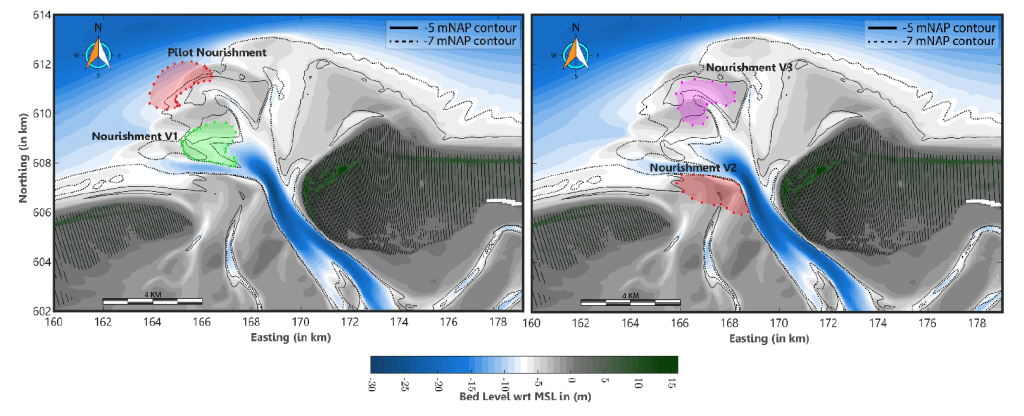
Ebb-tidal deltas are notoriously unpredictable. Battered about by waves and tides, their ever-shifting sands can be a royal pain in the arse for everyone from coastal residents to pirates. I have spent most of the past five years trying to identify the pathways that sand takes across these deltas as part of my PhD. However, the holy grail of ebb-tidal delta research is to take that one step further and make accurate morphodynamic predictions of their evolution on timescales of decades.
This past year, Denzel Harlequin took up the challenge, and I am pleased as punch to announce that last week he successfully defended his master’s thesis, ”Morphodynamic Modelling of the Ameland Ebb-Tidal Delta”. This is a really tricky problem to solve because of the complexity of the processes that need to be simulated.
What’s cool about Denzel’s work is that brings us closer to good morphodynamic predictions than we were before. Furthermore, where the predictions deviate from reality, he illuminates the areas where we still need to make improvements — specifically, our representation of wave-driven transports. Denzel also shows how the location of a sand nourishment can have major knock-on effects on the evolution of the ebb-tidal delta.
Different nourishment designs tested by Denzel. If you place the sand in a more dynamic area like a channel, it can have a much wider effect on the rest of the ebb-tidal delta.
Denzel is a very talented modeller and I am delighted that he has joined us as a new colleague in the Applied Morphodynamics department at Deltares. I look forward to many more great collaborations to come!


