

Keeping Dutch feet dry is mainly done by placing piles of sand along the coast as “nourishments”. These nourishments build out the beaches and dunes to act as a protective buffer against storms. However, as was recently pointed out by an official at Rijkswaterstaat, the Dutch water ministry, the Hamvraag or “bacon question” is still “where the heck does all that sand actually go?”
Knowing where nourished sand goes is important for understanding the ecological impact of nourishments, as well as their effectiveness. If you want your sand to reach a certain destination, how much of it actually gets there and how quickly?
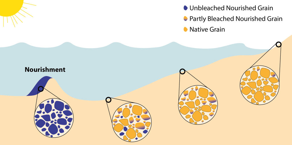
One of the ways that we are trying to answer this question in the TRAILS project is via a nifty approach called Optically-Stimulated Luminescence (OSL). My colleagues at Wageningen University (Anna-Maartje de Boer, Jakob Wallinga, and Liz Chamberlain) are experts at using this technique to estimate the date of sediment deposits. Essentially, every grain of sand has a light-sensitive signal called luminescence. This signal is “reset” or “bleached” when the grain is exposed to sunlight. In this way, they can estimate how long it has been since that grain last saw the sun. This also makes it a handy tool for archaeologists who want to figure out how old artifacts buried in a particular location are.
Underwater, it gets exponentially darker the deeper you go. Most of the sand that the Dutch use to nourish their coasts comes from sources deep offshore where the seabed is comparatively darker than close to shore. As such, my Wageningen colleagues hypothesize that nourished sand will have a different luminescence signature than the native sand nearshore. In this way we can track the dispersal of nourishment sand, using the nourishment itself as a tracer. This is a big deal because conventional tracer studies are really hard to carry out in these environments. They have tried something like this for a beach nourishment, and now we want to see if this method works for nourishments in deeper water.
I’m no specialist on luminescence dating though, so my hamvraag is “how can we use a numerical model to support the tracing of nourishments via OSL?” Today I am presenting my preliminary work on this topic at the annual American Geophysical Union conference in Chicago. To predict the “bleaching” of nourished sand grains, we need to know (1) where the sand grains are travelling, (2) how much light they are exposed to along their journey, and (3) how much exposure is required to bleach the grains.
To answer these questions, we started by taking measurements in the field. In February and May this year, my colleagues Tjitske Kooistra and Anna-Maartje de Boer went out to the Dutch Wadden Sea in a research ship to collect data about how quickly light attenuates in the water depending on how deep you go and how much sand and mud are floating around. You can read more about their field measurements here in Tjitske’s blog.
Their measurements confirmed that indeed, it gets darker more quickly if the water is muddier and sandier, as they saw in February when they measured after a succession of big storms. On the other hand, the water was much clearer in May when the weather was calmer, so the light could penetrate much deeper below the surface.
What does this mean for sand grains? We took this information and put it into a computer model that predicts how tidal currents move sand and mud around. With this model (SedTRAILS), we can predict the pathways that sand takes as it travels around the coast. From there, we can see how much light a given sand grain would experience as it makes its journey through the water.
The last remaining piece of the puzzle is to figure out how much light it takes to “bleach” a sand grain. My colleague Anna-Maartje is currently doing a series of clever experiments to measure this in the field. Once we have that information, we can include it in our model and predict how much nourished sand will bleach as it disperses. This information will help us interpret the luminescence signals of sand that we find on the seabed- did it come from a nourishment or was it already sitting there? We can also use this data to validate SedTRAILS and improve our confidence that it is correctly simulating the motion of the sand grains.
If you are interested in working together with Bram van Prooijen and I on this at TU Delft, get in touch with me at s.g.pearson@tudelft.nl! We will be looking for a postdoc to collaborate with us on this topic in the new year.

An excellent article Stuart that I could understand. I hope your presentation is well received
LikeLike