Sand: Clatsop Beach, Oregon

Today’s sand sample is from Clatsop Beach, Oregon, on the Pacific Northwest coast of the US.  Last summer I spent several months modelling sediment transport at the mouth of the Columbia River with the US Geological survey, and had the great privilege of making a site visit at the end of my stay.

Working in partnership with Oregon State University and the Washington State Department of Ecology, I assisted with a topographic survey of the beaches surrounding the Columbia.  Half the team surveyed the submerged parts of the beaches via jetski, and my group walked transects across the beach and up the dunes using backpack-mounted GPS units.

Starting at far-too-early-in-the-morning, our team split off individually, and I had an entire kilometers-long stretch of the beach to myself until almost lunch time, when we reconvened.  I love long walks on the beach and take great pleasure in that sort of solitude in nature, and it was even cooler to do that while collecting data that could help the project I was working on.  The digital computer model I had worked on all summer was now suddenly a real place where I could feel the sand between my toes.

Gold in Them Hills

The sand at this beach is interesting because of the black grains we see scattered throughout.  This sediment is made of minerals like chromite, magnetite, and garnet, which are heavier than the whitish quartz grains we see around them.  These deposits, known as “placers”, were transported to the sea from the mountains inland by the Columbia River. They form on the beach because lighter minerals like quartz are preferentially sifted out by waves and currents, leaving more of the dense particles behind.   This even includes trace amounts of gold!  Can you see any in the photograph below?

ClatsopBeachOR_000001
Sediment sample from Clatsop Beach, OR.  Note the black “placer” deposits of heavy minerals.  Can you see any flecks of gold?

At the end of our survey, I walked along the beach to check out a surprising object emerging from the sand: the wreck of the Peter Iredale, a sailing ship that ran aground there in 1906:

petereyerdale
The Wreck of the Peter Iredale on Clatsop Beach.

Known as the “Graveyard of the Pacific“, the mouth of the Columbia is truly a “killer ebb-tidal delta”: huge waves and powerful currents meet violently, and have caused dozens of shipwrecks over the past few centuries.  This makes effective management of the sediment there crucial for safe navigation, keeping the shipping channel dredged clear and disposing of the sediment in environmentally-friendly, cost-effective, and useful ways.

wrecks
Historical shipwrecks at the Mouth of the Columbia River, seen in the Columbia River Maritime Museum.  

Strategic placement of this dredged sediment was the focus of my time at USGS last summer, but I will delve into that more in a future post!

Sand: UBC Cliffs/Wreck Beach

Vancouver holds a special place in my heart.  I was born out there, and even though we moved away when I was very young, it has continued to re-emerge in my life.  In 2011, I moved out there after a difficult breakup and the city breathed new life back into me.  While there, I discovered a new vocation in hydraulic modelling for predicting floods, something that I am still doing to this day.  I have returned to Vancouver a number of times since then, since my brother and a surprising number of my closest friends have ended up out there.  I hope to return this September for a wedding!

vancouver
Coal Harbour, Vancouver.

One of my favourite parts of Vancouver is walking its coastline.  The city was built on the edge of a large fjord, but has a variety of coastal landscapes, from towering cliffs to sandy beaches, mud flats to salt marshes, and of course a number of urbanized shorelines.

Even though I am in the Netherlands now, I am trying to keep my Vancouver connection alive through my work.  Last year, I co-supervised a fantastic group of TU Delft students who worked with Kerr Wood Leidal and the University of British Columbia (UBC) to investigate the erosion of the Point Grey cliffs, on which UBC is situated.

wreckbeach3
Eroding cliffs of Point Grey.  The University of British Columbia is at the top of the cliff, so naturally they are concerned with understanding the rate of erosion and means of slowing it.

The project was an interesting one, as the students (representing three different countries) tried to bring their lessons learned about Dutch coastal engineering to Canada.  Canadian coastal zone management is much more fragmented than in the Netherlands, where everything is more or less centrally controlled by the federal government.  The entire Dutch coastline is also incredibly well-monitored, with high resolution bathymetry taken every few years, and with countless other measurements available.  Acquiring the data necessary to perform a coastal engineering study in Vancouver required contacting dozens of different sources and dealing with numerous agencies at multiple levels of government.

UBCcliffs_000012
Sand from Wreck Beach.  It is quite coarse and angular in shape, and the green and red tints are quite nice. Being glacial in origin, these sand grains have likely been bulldozed by ice or carried by meltwater from far and wide.  This accounts for the variety of particles we see.

In the end, the students looked at a number of possible solutions for slowing the coastal retreat, including sand nourishments and revetments.  One of the most intriguing concepts that they explored was the idea of a clam garden, a traditional approach from the First Nations people living on the BC coastline.   Originally intended for aquaculture, clam gardens are usually small rock walls placed along gravel beaches, behind which where clam-friendly sand or mud can accumulate.  However, this approach could have added benefits for coastal protection by attenuating waves and encouraging the deposition of sediment.  In many ways, it is not that different from the Dutch using brushwood dams to reclaim land in the Netherlands or my colleagues using similar structures to rebuild mangrove habitats.

In Canada, the involvement of First Nations in coastal planning is becoming increasingly important (as I think it should be!), and there is a lot that science and engineering can benefit from their traditional forms of knowledge and experience.  Building with nature instead of fighting against it has recently become a popular design philosophy in coastal engineering, and who better to have as allies in that task than the people who have been living with and building with nature already for centuries?

wreckbeach2
World War II-era bunker on Wreck Beach overlooking the Georgia Strait, with North Vancouver in the background.


The Delft-Vancouver connection continues: right now we have a group of five students investigating coastal protection solutions with Kerr Wood Leidal and the Tsleil-Waututh Nation.  They have already been out there for a month, and I am excited to see what they come up with!

spanishBanks
Sunset over the Spanish Banks, just around the corner from UBC.

Singing Sand: Cannon Beach, Oregon

This week we have some sand from Cannon Beach, Oregon, which is most famous for this big, beautiful rock:

CannonBeach
Haystack Rock on Cannon Beach, Oregon.

Located on the Oregon coast just south of the Columbia River mouth, I passed through Cannon Beach last summer on my drive to Vancouver.

The most peculiar thing about this sand was that it squeaked when I walked on it. You read that correctly- it made a squeaky noise when you stepped in it, which was a delightful surprise.  I had heard about this phenomenon before, but never experienced it myself.  “God, that’s weird!” says one Youtuber after running their hands through the sand at Cannon Beach:

This “singing sand”, is due to localized shear: as you step into the sand, it causes the grains to rub past one another and generate sound [Humphries, 1966].  This tends to happen if the sand grains are well-sorted (all more or less the same size) and highly spherical [Lindsay et al., 1976].  In the photograph below, the sand grains don’t look particularly spherical, but they are indeed quite consistent in size (just compare with one of the more poorly-sorted samples we looked at in previous weeks).

CannonBeachOregon_000001
Squeaky sand from Cannon Beach, Oregon.

However, sand does not always sound so cute: it can also make apocalyptic booming noises“Booming sands” have been documented before in sand dunes, sounding like the world’s most enormous and terrifying swarm of bees. The sound seems to depend on the grain size and the layer of sand that is avalanching down the slope[Vriend et al., 2007], although there is still some debate about the actual mechanism.  

Something to think about the next time you hear a strange noise at the beach or in the desert!

Sources

Andreotti, B., Bonneau, L., & Clément, E. (2008). Comment on ‘‘Solving the mystery of booming sand dunes’’by Nathalie M. Vriend et al. Geophys. Res. Lett35, L08306.

Humphries, D. W. (1966). The booming sand of Korizo, Sahara, and the squeaking sand of Gower, S. Wales: a comparison of the fundamental characteristics of two musical sandsSedimentology6(2), 135-152.

Lindsay, J. F., Criswell, D. R., Criswell, T. L., & Criswell, B. S. (1976). Sound-producing dune and beach sandsGeological Society of America Bulletin87(3), 463-473.

Vriend, N. M., Hunt, M. L., Clayton, R. W., Brennen, C. E., Brantley, K. S., & Ruiz‐Angulo, A. (2007). Solving the mystery of booming sand dunesGeophysical research letters34(16).

Sand: Barra, Scotland

A few weeks ago, I shared some sand that my dad brought back from the Butt of Lewis.  On that same trip, he and my mom went to visit the island of Barra, where her family originated from before emigrating to eastern Canada in the 1770s.

Halfway through their holiday, I received an excited text message from my dad: “Tell me – the whole island seems like grey granite, so where does the white sand come from? (In fact all the west side beaches are white sand.) Is it coral?”

Eager for a distraction from my work, I did a quick lit review. The consensus seems that indeed, the white sand on the beaches has almost nothing to do with the gneiss found on the rest of the island.  In essence, it seems as though most of the original sand was bulldozed there by glaciers during the last ice age or brought there by meltwater as they retreated.  Then over the course of the past few thousand years, shell fragments have accumulated and overwhelmed the native glacial sand, making up 7.5% to 82.9% of the total sand.  This results in the beautiful white beaches that you see today (Jehu & Craig, 1924; Goodenough & Merritt, 2007).

This might be my favourite sample of sand that I have analyzed yet- it is incredibly shelly, and every photo reveals beautiful new shapes and patterns. I think I will just let the sand speak for itself:

BarraHotel_000018
When you zoom out, it doesn’t look like much…
BarraHotel_000000
…but zooming in reveals all sorts of interesting shell fragments with different structures and colours.

BarraHotel_000001

BarraHotel_000002
I particularly love the piece in the middle of this photo: it almost looks like a piece of glazed pottery.

BarraHotel_000004

I love the spiral shells.  Last summer I read a really cool book about the evolution of mollusks and seashells: Spirals in Time: The Secret Life and Curious Afterlife of Seashells.  Worth a read if you like this sort of thing!

BarraHotel_000005
I’m really quite curious as to what the red and white fragment in the upper left quadrant is. It looks like a piece of octopus tentacle, although I know it can’t be!
BarraHotel_000007
Purple is my favourite colour, so I love the shade of the fragment in the lower left corner. It actually looks a lot like the coralline algae we saw in my photographs of sand from Archipel Glenans.  I wonder if something similar is present offshore of Barra… The cylindrical fragment on the right side makes me think of a Roman column.

BarraHotel_000008

BarraHotel_000009

BarraHotel_000012
This one might be favourite- I zoomed in to 40x magnification to take a closer look.  The patterns of the white bubbles are beautiful- I am very curious whether that is a shell fragment or actually some sort of igneous rock left over from Scotland’s volcanic days

BarraHotel_000013

BarraHotel_000014

BarraHotel_000017
I love the iridescence of the shell at mid-right, and the vivid pink streak in the top left quadrant.  So many cool shapes and colours!

I hope you enjoyed those as much as I did.  I just wish I knew more about ecology so that I had a better idea of what we were actually seeing here!

Sources:

Goodenough, K., & Merritt, J. (2007). The Outer Hebrides: a landscape fashioned by geology. Scottish Natural Heritage.

Jehu, T., & Craig, R. (1924). XXII.—Geology of the Outer Hebrides. Part I.—The Barra Isles. Transactions of the Royal Society of Edinburgh, 53(2), 419-441.

Sand: Ardrossan, Scotland

I recently paid a visit to my grandmother in Glasgow, Scotland.  She is 94 1/2 years old and is still a delight to be with.  Since she is living in a retirement home now and doesn’t get out much these days, I rented a car and we went for a drive together down the coast to Troon:

On our way back to Glasgow I pulled over the car in Ardrossan and grabbed a handful of sand from the beach there:

NearTroonScotland_000001.jpg
Sand from the beach at Ardrossan, Scotland.  It appears to be fine, well-rounded quartz sand.  Note the beautiful red tint of the grains.

When I showed my dad this photo, he pointed out that the pink sand grains resembled the red sandstones found in houses and buildings all across Glasgow, the city where he grew up.  When I looked into it further, it seems that many of the sandstone bricks used in facades across the city indeed came from Ayrshire, where this beach was located.  This is backed up by a geological map of the Firth of Clyde, which shows our little beach  comfortably inside the red sandstone zone.  A delightful convergence of sediment and architecture!

Scotland A 038.jpg
The Kelvingrove Gallery, one of my favourite places in Glasgow.  If you ever find yourself in Glasgow I highly recommend it- it’s free! Note the beautiful red sandstone facade.

That’s one of my favourite things about this field- there always seems to be new and interesting connections back to other things that I love!

Scotland C 055.jpg
Majestic highland cows in Pollock County Park, Glasgow.  Note their beautiful red sandstone facades.

Sources:

Jardine, W. G. (1986). The geological and geomorphological setting of the estuary and Firth of Clyde. Proceedings of the Royal Society of Edinburgh, Section B: Biological Sciences, 90, 25-41.

Sand: Xerokambos Beach

My friend Claudia responded with great zeal to my call for sand from different beaches around the world.  In addition to her samples from Sword Beach and Dunkirk, she also brought back sand from her holiday to the Greek island of Crete.  The sand from Xerokambos Beach is interesting compared to those two French beaches, since it is much more diverse- there are many different colours and likely different mineral origins for the sand grains that we see there.

xerocambos_000002

That being said, when I see pictures of how lovely Crete looks, I have the feeling that I would not be too focused on the finer details of local sand composition if I went on holiday there!

Sand: Archipel Glenans

Ga je naar het strand? Mag ik
als je terug komt het zand
uit je schoenen voor
de bodem van mijn aquarium?

Are you going to the beach?
when you come back, may I have the sand
from your shoes for
the bottom of my aquarium?

– K. Schippers

I have had that Dutch poem on a postcard on my bedroom wall for a few years now, but it unexpectedly came to life a few weeks ago.  I mentioned to some friends that I was taking pictures of sand from different beaches with a microscope and wanted to expand my collection.  My colleague Silke enthusiastically responded- she had just returned from a holiday in France and still had sand in her shoes!  “Should I bring it to the office tomorrow?” she asked.  How could I say no?

archipelGlenans_000002

Her holidays had taken her to the beautiful Glenans Archipelago off the coast of Brittany, not too far from where I am living right now in Brest. Unlike a lot of the sand I have looked at so far (which was mainly quartz), this beach appears to be quite shelly.  The islands are famous for their maerl beds, a sort of coral algae rich in limestone.  That may account for some of the interesting shapes and colours we see, but if you look closely, it seems there are also some threads and bits of lint from Silke’s socks!  It might not be a scientifically valid sample, but I’ll take it!

archipelGlenans_000006

Sand: Dunkirk Beach

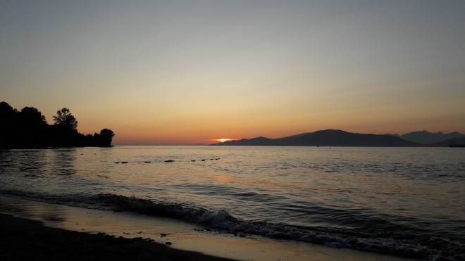
Here is another sample brought back by my friend Claudia, from Dunkirk Beach in northern France.  Dunkirk is famous from the Second World War, when the Nazis had cornered Allied troops there and forced a major evacuation across the English Channel.

dunkirk_000003

This is where my inner history nerd and my inner sand nerd collided to ask an interesting question: is the sand on that beach now (and in the photograph below) the same sand that was on the beach during the famous evacuation?  There’s no easy answer to that question, but as it so closely relates to the main research questions of my PhD, I can’t resist indulging in such a thought experiment.  Shall we try together?

To answer this question, let’s ask ourselves a few things:

  1. What kind of sand is on the beach?
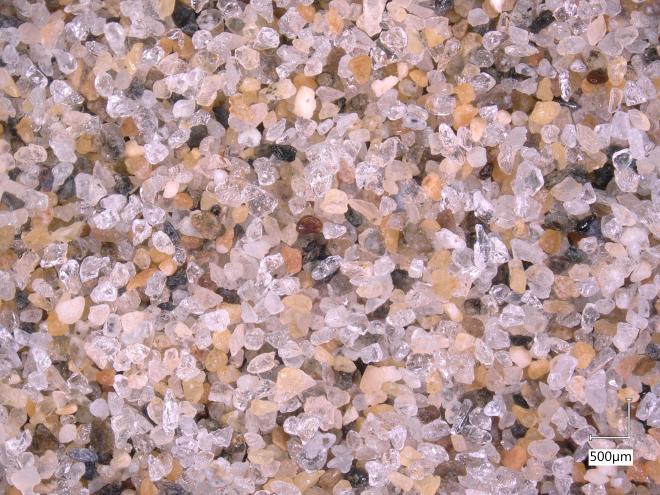
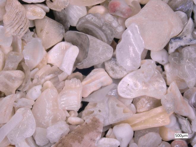
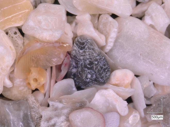
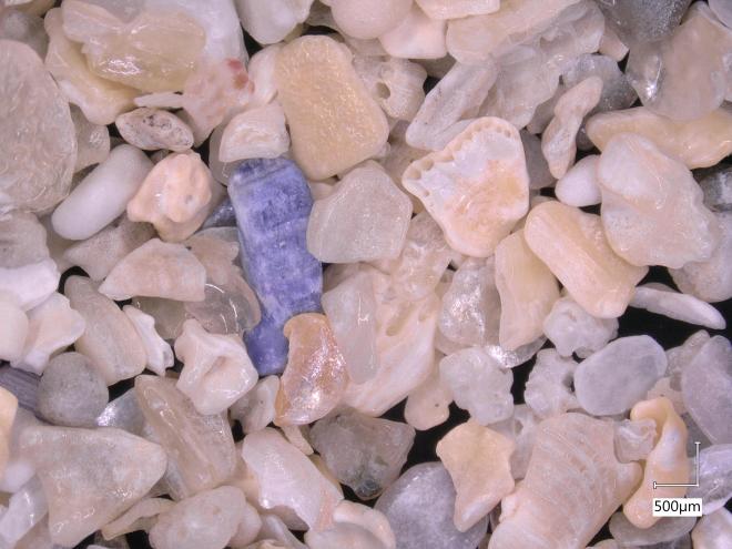
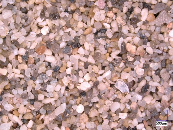
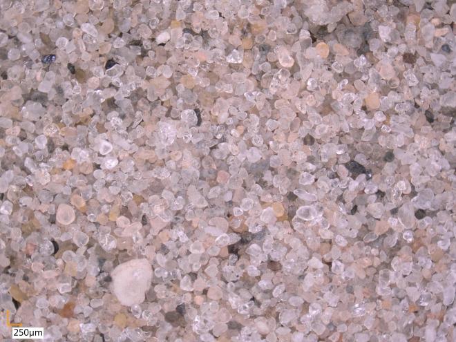
    The size of the sand grains will determine how easily it is moved around by the waves and tides.  Bigger particles require more energy to move, and are thus more likely to stay where they are.  In general, smaller sand grains are more likely to get picked up and transported far away*.  Based on the photo above, let’s assume that most of the sand grains are about 200 μm in diameter (that’s 0.0002 m).
    The sand also seems to be mainly made of clear or white-brownish grains, so we can probably make a safe guess that they are mainly made of quartz.  This will come in handy later if we need to make an assumption about how dense the particles are. Most of this sand comes from large sand banks offshore, which is moved to shore by waves during large storms [1].
  2. How do waves and tides shape the coastline here?
    To predict how sand moves around on a beach, we need to understand the behaviour of the water there.  The tidal range on this part of the French coast is quite large, between 5-8 m [1]. That large range means that a correspondingly massive volume of water is moved back and forth past the beach twice a day, which generates powerful tidal currents.  Waves here mainly come from the English Channel to the west or the North Sea to the northeast, and are generally at their strongest during occasional winter storms.
  3. In which direction does the sand usually move?
    There are several possible fates for our 1940 sand: (a) staying where it is, (b) moving offshore into the English channel, (c) moving westward towards Calais, (d) moving eastward to Belgium, or (e) moving onshore to build up the sand dunes there.
    At these beaches, the tidal currents moving eastward towards Belgium are slightly stronger than the ones moving westward back towards England [1].  This is eastward motion is reinforced by waves and wind-driven currents, which also tend to move eastward on average [2].  As a result, the sediment effectively takes two steps forward and one step back, gradually moving in an eastward direction (i.e. (d) rather than (c)).
    We also know that there is a regular supply of sand from offshore [2], so let’s rule out (b) for simplicity. The dunes in that area are also relatively stable [2], so let’s rule (e) out, too.  If most of the sand is then either moving east (d) or staying put (a), what is the likelihood that our 1940 sand is still there?
  4. Have humans intervened with the coast there?
    In 2014, the French government created the largest sand nourishment in the history of France on the beach at Dunkirk [3].  This is visible in Google Earth as the giant pile of sand near the red pin (below).  If there was still 1940 sand on the beach there, it is now likely buried underneath the nourishment.  Depending on where my friend collected her sand, there is a good chance that it is made up of this sand that was dredged from the nearby harbour, rather than sand that was on the beach in 1940.

    I had a similar issue with my tracer study: several months after our investigation, the Dutch government placed a huge nourishment right on top of our study site.  That means that even if some of our tracer sand is still out there, it is likely buried deep beneath a giant pile of sand, which means that we can’t go back there to take more samples.
  5. What is the likelihood of sand leaving the beach?
    After placing the nourishment at Dunkirk in 2014, scientists monitored how the beach changed, and found that it lost 9% of its volume in 2 years [3].  Most of this sand appeared to migrate eastward, as predicted by those other studies.  If we had similar data about how much the volume of the beach has changed in the past 80 years, we could estimate the rate at which sand is leaving, and hence how likely it is to still be there.  From that, we could come up with a sort of “residence time”: how long we expect sand to remain on the beach given the volumes that are coming in from offshore sandbars and leaving down the coast.  That would at least give us a ballpark idea of what to expect.  We could also use computer simulations to more precisely predict this transport, but that’s a lot of work for our little thought experiment!

Given all of this information, I would guess that most of the sand that was on the beach in 1940 is somewhere on its way to Belgium, or is still there but buried beneath the new nourishment.  Based on the assumptions that we made about this being quartz sand about 200 μm in diameter, we can estimate that in a handful of sand (say, 250-300 mL), there will be about 5 million individual grains!** If we scale this up to an entire beach, then I think the odds are good that at least a few grains have stuck around since then.

There are lots of different ways that you could go about this, though- how would you try to tackle it? Am I missing anything important?


* This “smaller-particles are more likely to get picked up by the waves and currents” rule only works for sand grains that are all more-or-less the same size. If your sand has both large and small particles, you can also have “hiding” effects where little grains of sand hide behind big grains and are harder to move. And don’t even get me started on mud! Mud particles (usually 10-100 times smaller than sand) obey a whole other set of complicated rules that are frankly a little absurd sometimes. But these are discussions for another time…

** Even though the grains in that picture are clearly a bit irregular in shape, we can pretend that they are spheres and calculate their volume Vgrain = 4/3π(0.0002/2)3 = 3.3×10⁻¹¹ m3.  The volume of your hand Vhand is 300 mL = 3×10⁻⁴ m3, so we can calculate the number of grains as Vhand /Vgrain, which is about 9 million. But wait! We have to account for all the spaces in between the sand grains, since we’re not dealing with a solid block of quartz. This is usually about 40% for sand, so this is how we get our final number of about 5 million.


[1] Sabatier, F., Anthony, E. J., Héquette, A., Suanez, S., Musereau, J., Ruz, M. H., & Régnauld, H. (2009). Morphodynamics of beach/dune systems: examples from the coast of France. Géomorphologie: relief, processus, environnement15(1), 3-22.

[2] Anthony, E. J., Vanhee, S., & Ruz, M. H. (2006). Short-term beach–dune sand budgets on the north sea coast of France: Sand supply from shoreface to dunes, and the role of wind and fetch. Geomorphology81(3-4), 316-329.

[3] Spodar, A., Héquette, A., Ruz, M. H., Cartier, A., Grégoire, P., Sipka, V., & Forain, N. (2018). Evolution of a beach nourishment project using dredged sand from navigation channel, Dunkirk, northern France. Journal of Coastal Conservation22(3), 457-474.


Sand: Nourishment at Ameland

The main protective barrier for the Netherlands against the threat of flooding from the sea is a row of colossal sand dunes and wide beaches that stretch the length of their coast.  However, that barrier is not completely natural —  since the Dutch coast is in a constant state of erosion, the sand in their coastal zone has to be continually replenished.  This replenishment takes the form of nourishments, which are essentially just massive piles of sand placed on beaches, dunes, or just offshore.  The Dutch are lucky, since the bottom of the North Sea is covered in sand for hundreds of kilometers in every direction, meaning that there is a ready supply available for this purpose.

Although we still have plenty to learn about how to construct these nourishments effectively and in an environmentally friendly way, we are starting to get the hang of it — at least for long, straight, sandy coastlines like in Holland.  However, this all gets a bit trickier when we turn our attention to the Wadden Islands dotting the northern coast of the Netherlands.  These little islands sit between the stormy North Sea and the shallow Wadden Sea, a large estuary whose ecological value is unmatched in the Netherlands.

The coast of these islands is punctuated by a series of inlets connecting the two seas.  Chaos reigns at these inlets, where strong tidal currents pass in and out, clashing with waves and whisking sandy shoals in and out of existence in unpredictable ways.  This makes the inlets treacherous for ships, but also a challenge to simulate with our computer models and design nourishments for.

How, then, are are we meant to nourish the coast of these islands?  We want to keep their inhabitants (and those on the nearby mainland) safe from flooding, but also need to be careful about inadvertently disrupting the vital ecological habitat of the Wadden Sea.

To answer that question, the Dutch government initiated the Kustgenese or Coastal Genesis project. In collaboration with several Dutch universities, companies, and research institutes, they set out to better understand how these tidal inlets work, and whether it is possible to effectively nourish them.  The project focuses on Ameland Inlet, which is located between the islands of Ameland and Terschelling.


My PhD project is but a very tiny piece of the very large Kustgenese pie.  My goal is to figure out specifically how the size of sand grains affects the paths that they take around tidal inlets.  It has been the dream job for someone who has loved playing in the sand ever since he was a little kid.  As a result, it has entailed a lot of time at my computer and in the laboratory, investigating the characteristics of the sand in Ameland inlet (that’s also why I have so many pictures of sand on this blog- we have a really cool microscope!).  It is very fine sand and would be absolutely perfect for squidging your toes through on a hot day — if it weren’t at the bottom of the sea, that is:

NativeSediment
Native sediment from Ameland ebb-tidal delta

In the spirit of ‘why not?’, the Dutch government decided that the best way to test whether nourishments would be effective in this environment was to just go ahead and try one out last year.  They dredged up 5 million cubic metres of sand (that’s enough to fill 3 Skydomes, for anyone reading this back home in Toronto) and placed them just outside the inlet.  A few months ago, one of the Dutch government officials showed up at a meeting with a “present” for me… some sand from the nourishment!

NourishmentSediment
Nourishment sediment dredged from offshore and placed on Ameland ebb-tidal delta.

Needless to say, I was very excited.  At first glance, it appears quite similar to the native sediment, so that means it should behave in a similar manner.  Time will tell how the nourishment evolves- we are watching very closely!

Sand: Tracer Sediment

I have spent many months holed up in the laboratory counting green grains of sand. Last year we dumped over 1 ton of fluorescent, magnetic tracer sand into the North Sea, where the waves and tides then scattered them along the coast. We then spent the following weeks circling around on a boat to try and find it all again. We scooped up over 200 samples of sand from the seabed, then brought them back to the lab for analysis. We used a super strong magnet and blue UV light to separate the tracer (bright green) from the normal sand (looks grey or purple under UV light). This part is REALLY boring because most samples don’t have any tracer but we still have to look hard for it . But then we get to look at all the sand under a fancy microscope, which is my new favourite toy! Under the UV light, the tracer reminds me of little green constellations of stars in a purple night sky.

TracerSediment

The tracers glow bright green under ultraviolet lights.  On the top left we have a jar of normal beach sand sitting next to a jar of tracer.  The distinction becomes clear once we place them under UV illumination (top right). This is especially important when we analyze samples taken from the seabed, where there may be only a few grains of tracer (bottom left). The fluorescent properties of the tracer help it stand out from normal sand (bottom right), which lets us count the individual grains.

Fortunately, we can use computers to count the individual grains and tell us their size.  With this information, we can estimate how the size of a sand grain determines how far and fast it will travel.  This is important for planning sand nourishments to protect the coast.

G001-2017-08-30_000006

If we can figure out where the green tracer did (or didn’t) go, that will tell us how normal sand moves around on the Dutch coast. And this will hopefully keep our feet dry here in Delft for a long time to come!