When you think of coastal climate change impacts, what do you think of? Probably sea level rise, changes in wave climate or storminess, or loss of coastal habitat. But a silent intruder lurks: salty seawater, sneaking into estuaries and rendering our precious freshwater supplies undrinkable. The threat of estuarine salinity on deltas and coastal regions is one that I greatly underestimated, even as someone working in this field for over a decade. That is, until Gijs Hendrickx came along.
My colleague Matthieu de Schipper and I are looking for a new PhD candidate as part of the large SOURCE research project! SOURCE stands for Sand nourishment strategies for sustainable Coastal Ecosystems. The SOURCE philosophy is that carefully planned sand nourishments now will create the required and desired resilient and dynamic multifunctional coastal landscapes of the future.
Sand nourishment has been essential in the Dutch government’s strategy to sustainably maintain flood protection levels along the Dutch coast for more than 30 years. Nourishment volumes are projected to increase to keep up with the expected acceleration in sea level rise. However, we currently lack fundamental knowledge on how the nourished sand finds its way through the coastal system, and what the long-term, cumulative effects are for the coast as an ecosystem. For instance, we know that beaches that are nourished with sand in the nearshore are eroding less, but which sediment is accumulating on the landward beach is still unknown. Likewise it is still unknown which hydrodynamic and sediment transport processes dominate in the vicinity of a nourishment.
In its entirety, the SOURCE research team will deliver the scientific knowledge, models and design tools to develop and evaluate nourishment strategies in a multi-stakeholder co-creation process. Our Living Labs are two sand nourishments along the Dutch coast. These will be co-designed, monitored and evaluated by the SOURCE consortium (in particular the 12 PhD and postdoc researchers at 8 academic institutes in total) in collaboration with 25 partners from government organizations, research institutes, nature organizations and industry.
As part of the SOURCE project, the PhD candidate at Delft University of Technology will examine the morphological development of shoreface nourishments. Understanding the hydrodynamics and sediment transport are key in this research. You will therefore use state-of-the-art field equipment and strategic numerical modelling to unravel the physical processes shaping nourishments. This will ultimately contribute to the robustness of (Dutch) sandy coasts to climate change and the safety of its people against flood hazards.
You will:
Plan, execute and analyse field observations at a nourished beach to better understand the impact of nourishments on the hydrodynamics, sediment transport, and morphological evolution.
Use strategic modelling to predict coastal sediment pathways at recently nourished beaches and the origin of sediment accumulated in the lee side.
Combine data and findings of multiple nourishment projects to show the link between engineering design and coastal settings on the nourishment performance. This step will require you to collaborate with government and industry partners (abroad).
Collaborate with academic partners in the SOURCE project to translate quantitative metrics of physical beach response to ecological and socio-economic impacts.
At TU Delft, you will be part of the Coastal Engineering section where we combine research on hydrodynamics, morphodynamics, and human interventions to the coast using numerical modelling and field measurements. You will primarily work with Matthieu de Schipper and myself (Stuart Pearson), embedded within a larger ecosystem of research partners.
More information about the topic and the application process can be found here.
Come join our team! Feel free to get in touch with us (s.g.pearson@tudelft.nl) if you have any questions. Applications close July 21st, 2024!
How can we ensure that vulnerable coasts and deltas remain robust to the effects of climate change? We need to better understand how sediment moves along our coasts and deltas, and plan to do so by treating coastal systems as networks of interconnected sediment pathways.
We are looking for a curious and motivated PhD candidate to work with us on an exciting project here at TU Delft in the Netherlands. The main goal of this position is to develop novel approaches to quantify sediment pathways and connectivity, and to use these approaches to inform coastal sediment management.
Our main strategy for ensuring the climate-robustness of the Dutch coast is to nourish or place sand to widen its beaches and dunes. However, the fate of sand placed on the coast is still poorly understood in the context of the full coastal system. Understanding where nourished sand goes is necessarily rooted in understanding the natural sediment transport pathways and connectivity of the system. To take advantage of advances in the field of network analysis and extend these concepts to analyzing sediment transport pathways in coastal systems, we established the framework of coastal sediment connectivity (Pearson et al., 2020).
In this project, you will advance coastal engineering by introducing established techniques from other fields (e.g., network analysis) in a novel way to understand and predict sediment transport. These techniques will yield a new and useful toolbox of methods for predicting and understanding sediment pathways, and enable more efficient and effective nourishment design and execution. This will ultimately contribute to the robustness of the Dutch coast to climate change and the safety of its people against flood hazards.
In this PhD, you will:
Apply network analysis techniques to better understand how sediment pathways are connected at small/short and large/long space/time scales.
Use coastal sediment connectivity networks to probabilistically model sediment pathways via Markov chains or machine learning approaches.
Quantify (a)synchronization of coastal sediment networks and relate to hydrodynamic forcing.
Relate quantitative metrics of network structure to practical coastal management goals (eg, identifying resilience or tipping points).
At TU Delft, you will be part of the Coastal Engineering section where we combine research on hydrodynamics, morphodynamics, and human interventions to the coast using numerical modeling and field measurements. You will primarily work with me (Stuart Pearson) and Ad Reniers, embedded within a larger ecosystem of research partners.
At the end of June, we will welcome a group of about a dozen American PhD students for our second annual IRES summer school, hosted at Deltares/TU Delft/Utrecht University and organized by the University of New Orleans and The Water Institute of the Gulf in Louisiana.
Last year we hosted 14 American PhD students for two (fully funded!) weeks in beautiful Delft. It includes D-Flow FM model training, cool field trips to sites around the Netherlands, a lab session, networking galore, guest lectures, and time for exploring the area. Last year everyone seemed to learn a lot and have a pretty good time (I sure did!). We have a great team and are excited to make it even better this year. Please share this with anyone in your network whom you know might be interested!
More details can be found in the pdf below. If you are interested you can apply here before January 27th, 2023. We will host the summer school for a third and final time in 2024, so if you are too late or ineligible this year, stay tuned for another chance next year!
At TU Delft, a requirement for our PhD defense is to make ten propositions based on what we have learned during the previous years. Claims posed by my friends and colleagues deal with the nitty gritty details (“All diffusive processes can be derived from an advective one, and failing to do so yields incorrect modelling“[1]) but also the bigger picture of how we do what we do (“The way morphological models are presented and interpreted has a lot in common with predictions of snow depth in five years on December 26th at 4pm. The knowledge in these models deserves a better presentation“[2]).
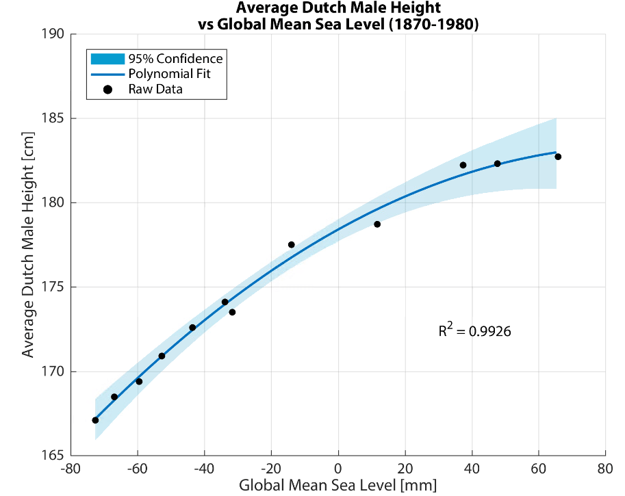
The propositions must be both defendable and opposable, so as to stimulate an interesting debate during the defense. Some of the propositions should reflect the findings of our research, but it is also traditional to include statements that have nothing to do with it. One colleague[3] even suggested (tongue in cheek) that the increase in the height of Dutch men over time could be explained by sea level rise. I couldn’t resist analyzing the data myself, and the results were surprisingly good:
Spurious correlation of the week! As John von Neumann said, “With four parameters I can fit an elephant, and with five I can make him wiggle his trunk.”
These propositions are a chance to inject a bit of last-minute philosophizing into our Doctorates of Philosophy, and range from the wise (“No wind is favourable if a person does not know to what port (s)he is steering – Seneca“[4]) to the downright cheeky (“This proposition is not opposable“[1]).
What I Learned by Counting Sand for 5 Years
As the clock is ticking on my own PhD (259 days, 13 hours, 39 minutes, and 51 seconds, but who’s counting? *eye twitches*), I started preparing some propositions of my own (obviously in a fit of procrastination on my dissertation). After nearly five years of scrutinizing sand and contemplating connectivity, my research has led me to an inescapable conclusion:
Ebb-tidal deltas are badass morphological features (BAMFs), (c.f. Phillips [2015]).
What, pray tell, is an ebb-tidal delta, and why is it so badass? Ebb-tidal deltas are large underwater piles of sand at the mouth of estuaries and tidal inlets, deposited by outflowing tides and reshaped by waves. I spend my days studying how waves and tides move sand around on the Ameland ebb-tidal delta in the northern part of the Netherlands (see below). We need to know this in order to plan ecologically-sustainable flood protection measures for the Dutch coast. A morphological feature is just a fancy name for some part of a landscape, like a hill or a valley or a beach.
An ebb-tidal delta is the giant pile of sand located at the mouth of a tidal inlet like this one. This may not sound glamorous, but understanding the way it moves around is extremely important for ensuring safe navigation and for predicting erosion and flooding of adjacent coasts.
What makes a badass “badass”?
Phillips[5] defines the archetypal badass as “individualistic, non-conformist, and able to produce disproportionate results”, and applies this concept to geomorphology (the study of how landscapes evolve, at the crossroads of geology and physical geography). Ebb-tidal deltas meet these three criteria, which makes them badass morphological features (BAMFs):
Ebb-tidal deltas are each unique (in shape, location, composition, and in terms of the environmental forces shaping them (like waves and tides)), and hence individualistic.
Ebb-tidal deltas are chaotic systems which defy accurate prediction using physics-based numerical models[6], and hence are non-conformist or “naughty”[7]. This numerical naughtiness is a serious problem for coastal engineers and scientists, since a failure to accurately predict ebb-tidal delta evolution can threaten public safety and lead to costly property or infrastructure damage. They do not “play by the rules” of our existing physics-based deterministic models.
Ebb-tidal deltas are highly nonlinear systems which can greatly amplify small instabilities[8], and hence produce disproportionate results.
In addition to the strict definitions of Phillips[5], ebb-tidal deltas are also “belligerent or intimidating, ruthless, and tough”, other traits reflective of badassery [Oxford Engish Dictionary]. The Columbia River ebb-tidal delta alone is responsible for dozens shipwrecks in the past century, and Ameland ebb-tidal delta has also featured numerous wrecks throughout its history.
Quoting Thomas Pynchon[9], Phillips also notes that badasses are “able to work mischief on a large scale”. Ameland ebb-tidal delta covers an area of approximately 100 square kilometers, roughly the size of The Hague. Many ebb-tidal deltas around the world are even larger!
Seriously?
Now admittedly, ebb-tidal deltas are just big piles of sand. A big pile of sand is probably not the first thing that comes to mind when you hear the word “badass”, unless you are Ralph Bagnold or a Sarlacc. This could probably also be considered gratuitous personification or anthropomorphization.
I’m sure that many of my friends and family have been scratching their heads as to why I would sacrifice the latter half of my 20s to understand them better. A critical reader might ask, “is it possible that you have only convinced yourself that ebb-tidal deltas are cool out of self-preservation?” And the answer is yes. Yes, I have. Nonetheless, I remain steadfast in my assertion that ebb-tidal deltas exhibit major symptoms of geomorphological badassery.
Although the concept of geomorphological badassery may seem silly at first, it illuminates several important truths of our (mis)understanding of these complex bathymetric features. Ebb-tidal deltas are important to study for reasons of coastal flood protection, navigational safety, and ecological value, but we are bad at predicting how they will evolve. This is because each ebb-tidal delta is unique, making it challenging to generalize their behavior. Furthermore, their chaotic, non-conformist behavior renders many of our usual deterministic prediction techniques ineffective. Lastly, the amplifying effect of highly nonlinear physical processes means that small physical changes (e.g., the development of a tiny shoal) could have disproportionately large consequences (e.g., relocation of a channel several kilometers wide). As such, badassery provides a useful conceptual framework for describing the challenges presented by ebb-tidal deltas to coastal engineers and scientists.
What’s it about? As sand moves along coasts and through estuaries, the pathways it takes are determined by a complex combination of waves, tides, geology, and other environmental or human factors. These pathways are hard to analyze and predict using existing approaches, so we turn to the concept of connectivity.
What is connectivity? Connectivity represents the pathways that sediment takes as a series of nodes and links, much like in a subway or metro map (see here for a primer). This approach is well used in other scientific fields like neurology, oceanography, and fluvial geomorphology, but in our study we apply these techniques to coastal sediment dynamics.
So what? To show how the sediment connectivity approach can be used in practice, we map sediment pathways with it at Ameland Inlet, an estuary in the Netherlands. The statistics we compute using connectivity let us quantify and visualize these sediment pathways, which tells us new things about the coastal system. We can also use this approach to answer practical engineering questions, such as where to place sand nourishments for coastal protection. We hope to use sediment connectivity to predict the response of our coasts to climate change, and the human adaptations that these changes provoke.
A conceptual summary of our paper on sediment connectivity at Ameland Inlet in the Netherlands.(a,c) We can schematize the sediment transport pathways in an estuary as a series of nodes (A,B,C,…) and the links connecting them. (b) This network can in turn be represented by a matrix, showing where the sediment is coming from (a source) and where it’s going to (a receptor). In this form, we can investigate questions like, “where does the sand in node F go?” (d), or “where does the sediment reaching node D come from?”(f). In my research, we are most interested in answering questions like, “what is the main pathway between the two islands, node A and G?” (e). We can also learn how the system is organized into “communities” that share sand (g), and how that changes when pathways are added or removed (h).
It has been a long journey, beginning with The Magical Figure that Changed My Entire PhD and now culminating in this publication. I am especially indebted to my supervisors, Bram van Prooijen and Zheng Bing Wang, for their constant support. I am also grateful to my other co-authors, Edwin Elias from Deltares and Sean Vitousek at USGS, for seeing potential in this approach and really strengthening and clarifying my story. I was also blessed with curious and constructive reviewers who provided a much-needed non-engineering perspective on our work.
Now that this paper is out, the fun can really begin! I have lots of fun ideas for applying connectivity to other estuaries around the world including the Mouth of the Columbia River and San Francisco Bay. We are also in the process of developing new modelling tools that well help us better unravel how estuaries and coasts are connected. Stay tuned!
Sources:
Pearson, S.G., van Prooijen, B.C., Elias, E.P.L, Vitousek, S., & Wang, Z.B. (2020). Sediment Connectivity: A Framework for Analyzing Coastal Sediment Transport Pathways. Journal of Geophysical Research: Earth Surface. [Link]